Backcountry Books
Backcountry Ski Map: Taos, New Mexico | Beacon Guidebooks
Backcountry Ski Map: Taos, New Mexico | Beacon Guidebooks
Couldn't load pickup availability
Backcountry Ski Map: Taos, New Mexico is a ski touring, splitboarding and off piste map to Taos, New Mexico by Beacon Guidebooks.
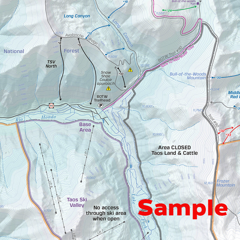
From mellow glades to technical lines, all the routes for this iconic backcountry skiing terrain are drawn in detail on this waterproof, foldable, topographic ski map. Tack it on your wall, or put it in your pack. No batteries required!
With an abundance of zones surrounding Taos, this map offers the entire spectrum of terrain and difficulty. Provided you already have a small amount of experience as a backcountry skier and have a level of avalanche knowledge, there is something in this area for everyone.
This 1:24,000 scale map written and reviewed by professionals covers it all with ski descents and uptracks, trailheads, parking information, approaches, resort boundaries, run list, slope angles, Avalanche Terrain Exposure Scale ratings, and inset photos of Taos Ski Valley sidecountry. Designed to go along with you on your tours and accompany the Backcountry Skiing Taos + Santa Fe Ski Atlas and Ski App.
This 18” x 22” waterproof, foldable topo map includes the following zones: Long Canyon, Fangorn Forest, Goose Lake + Gold Hill, Gavilan, Taos Ski Valley North, Middle Fork of the Red River, Horseshoe Lake + Lost Lake, Wheeler Peak East Fork Bowl, The Fingers, Red Rocks, Wheeler Peak West Face, Kelsey’s Stash, Sin Nombre, South W (SE Cirquie of Lake Fork Peak), North W (NE Cirque of Lake Fork Peak), Wildy Bowl
WATERPROOF | TEARPROOF | 1.5 OUNCES | 4″ X 5.5″ (folded) | 18″ x 22″ (open)
Please note - all Beacon Guidebooks are dispatched direct from Beacon in the U.S.A. Therefore they may arrive separately to other items on an order that contains multiple items.
Share