Backcountry Books
Backcountry Ski Map: Olympic National Park, Washington | Beacon Guidebooks
Backcountry Ski Map: Olympic National Park, Washington | Beacon Guidebooks
Couldn't load pickup availability
Backcountry Ski Map: Olympic National Park, Washington is a ski touring, splitboarding and off piste map to Olympic National Park, Washington by Beacon Guidebooks.
From Maggie’s to Klahhane, from low angle glades to mandatory rappels, all the routes in this awe-inspiring terrain are drawn in detail on this waterproof, foldable, topographic ski map. Tack it to your wall or put it in your pack. No batteries required!
Since the mid 1930s, backcountry enthusiasts have been exploring the terrain around Hurricane Ridge, Deer Park and the Bailey Range in the Olympic Mountains. Today, skiers and riders can enjoy relatively easy access to amazing lines from the Hurricane Ridge Road in Olympic National Park for a true sea to sky experience. From easy access day tours to bucket-list adventures, this accurate and extremely useful ski map will help increase your understanding of the terrain so that you can plan a successful and smart tour.
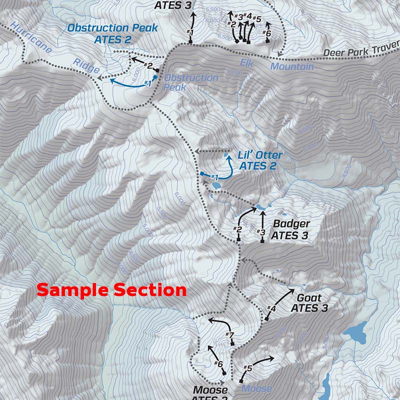
This 1:24,000 scale map written and reviewed by professionals details ski descents and uptracks, trailheads, parking information, slope angles, resort boundaries, Avalanche Terrain Exposure Scale ratings, and so much more. Designed to go along with you on your tours and accompany the Backcountry Skiing Olympic National Park Ski Atlas and Ski App.
This 18” x 22” waterproof, foldable topo map includes the following zones: Rocky Peak, Roadside, Klahhane, Silver Fir + Angeles South, Angeles West + Super Bowl, Darkside, Mount Angeles Circumnav, Visitor Center + Kingdome, Maggie’s + 20th of June, Mustang Bowl + North Bowl, Ski Area, Sunrise + Cox, Hurricane Hill South & North, Steeple rock North, + South, Steeple Rock Burn, Obstruction Peak, Eagle Point + PJ’s, Eagle Point North, Elk Mountain, Deer Park South & North, Deer Park Traverse, Lillian Ridge through Moose Peak, L’Otter, Badger, Goat + Moose, and Moose Peak West.
WATERPROOF | TEARPROOF | 1.5 OUNCES | 4″ X 5.5″ (folded) | 18″ x 22″ (open)
Please note - all Beacon Guidebooks are dispatched direct from Beacon in the U.S.A. Therefore they may arrive separately to other items on an order that contains multiple items.
Share