Backcountry Books
Backcountry Ski Map: Mount Baker, Washington | Beacon Guidebooks
Backcountry Ski Map: Mount Baker, Washington | Beacon Guidebooks
Couldn't load pickup availability
Backcountry Ski Map: Mount Baker, Washington is a ski touring, splitboarding and off piste map to Mount Baker, Washington by Beacon Guidebooks.
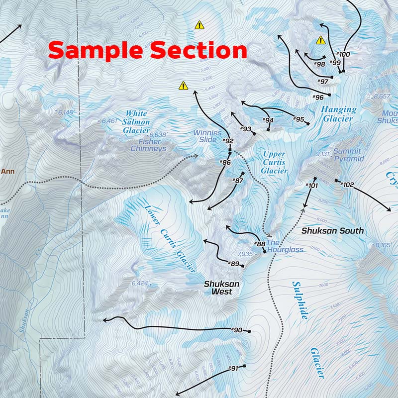
From Bagley to the Coleman Headwall, from low angle glades to mandatory rappels, all the routes for this year-round skiing mecca are drawn in detail on this waterproof, foldable, topographic map. Tack it to your wall or put it in your pack. No batteries required!
Mount Baker, known for its deep snowpack, super accessible year-round touring and chill local scene, is one of the premier outdoor playgrounds in North America. Along with the fully revised and updated guidebook, the newly released ski map includes 49 new and expanded routes in 10 new zones with remastered details and cartography. From entry-level day tours to bucket list adventures, the Backcountry Ski Map brings it all to your hands in a 1.3 oz. compact pocket companion.
This 1:24,000 scale map written and reviewed by professionals is designed to join you on your tour and details ski descents and uptracks, trailheads, parking information, slope angles, resort boundaries, Avalanche Terrain Exposure Scale ratings, and so much more. In addition to the 150 Descents, approaches, exits, high routes, and circumnavigations, author Matt Schonwald addresses each zone’s terrain as it relates to terrain traps, convexities, glacier travel and other avalanche hazards to keep in mind in each given zone. Designed to go along with you on your tours and accompany the Backcountry Skiing Mount Baker Ski Atlas and Ski App.
This 18” x 22” waterproof, foldable topo map includes the following zones: Bagley Lakes, Swift Creek, Shuksan Arm, Mount Ann + Annette, Herman Gulch, Ptarmigan Ridge, Iceberg + Mazama, Table Southwest Face, Barometer Mountain, Mount Herman, Herman + Stoneman, Slate Mountain, Shuksan, Mt. Baker (East, West, North, South), Goat Mountain, Winchester + Larrabee, Ruth + Icy, and the Twin Sisters Range.
WATERPROOF | TEARPROOF | 1.5 OUNCES | 4″ X 5.5″ (folded) | 18″ x 22″ (open)
Please note - all Beacon Guidebooks are dispatched direct from Beacon in the U.S.A. Therefore they may arrive separately to other items on an order that contains multiple items.
Share