Daisetsuzan Backcountry Map features routes and info about backcountry skiing in the Daisetsuzan National Park in central Hokkaido. This is a non-profit initiative, with a portion of HokkaidoWilds.org’s profit from the map to be donated to mountain safety and sustainability initiatives in Hokkaido.
Daisetsuzan Backcountry is the first-ever 1:25,000 English topographic ski map covering the Tokachi Range and Daisetsuzan Mountains (Asahidake and Kurodake) in central Hokkaido. Featuring over 30 classic backcountry routes, it’s based on high-resolution Japanese government data and expert field research.
The map includes detailed safety, weather, and access info, plus aerial photos and QR links to full route guides on HokkaidoWilds.org. Printed in Japan on tear-resistant, waterproof, recyclable paper (66 × 97 cm; folded 11 × 22 cm).
Coverage: Furano-dake, Sandan-yama, Tokachi-dake, Biei-dake, Oputateshike, Asahidake, Kurodake, and the Daisetsuzan Plateau.
Route Types
Ski-tour
Freeride
Expert
Map features
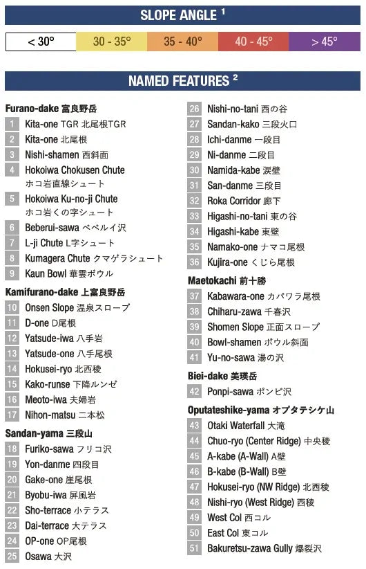
30+ backcountry ski routes, including ascent and descent routes
Slope angle shading for preliminary avalanche terrain travel planning
Place names in English and Japanese
Includes entire Tokachi Range plus the northern end of the Daisetsuzan Mountain range
Includes popular Asahidakesidecountry runs
Features an easy-to-use 1km UTM grid for ease of planning and on-the-ground location communication using international-standard grid references