Backcountry Books
Backcountry Whistler | Map & Guide to the Whistler Backcountry
Backcountry Whistler | Map & Guide to the Whistler Backcountry
Couldn't load pickup availability
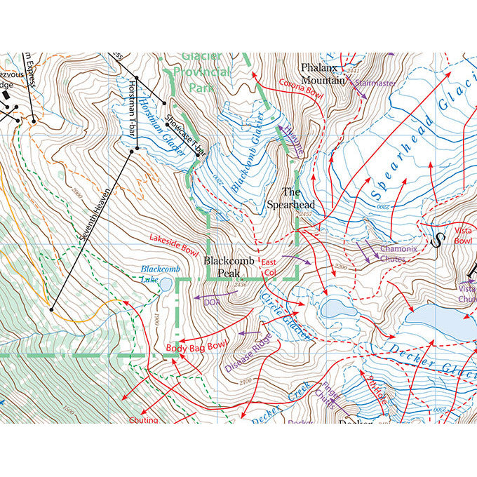
Backcountry Whistler is a topographic route map for backcountry skiing and snowboarding in Garibaldi Park, immediately adjacent to Whistler Blackcomb ski resort.
Backcountry Whistler shows the best and most popular backcountry skiing routes and descents in Garibaldi Park and the immediate Whistler backcountry. The map has a very detailed scale of 1:25,000 and clearly shows lines of descents using lines and arrows.
Important features like the Whistler Blackcomb lifts are also shown, along with the new Kees and Claire Hut and other useful landmarks. The names of popular lines and descents are also marked on the map.
On the map's reverse the author John Baldwin has included a huge amount of general info about the region including snowfall, avalanche and access concerns. There are also several written descriptions of popular descents in the region including those around Singing Pass, on Fissile Peak and the classic Spearhead Traverse.
Much more than just a map, this is a brilliant resource for the backcountry skier heading to Whistler. It works well when used in conjunction with John Baldwin's guidebook Exploring the Coast Mountains on Skis.
- 2nd edition
- Tear and waterproof paper
- Scale 1:25,000
- Contour interval 20m
- 30 colour photographs
- 11,000 words of text
Share